GUIDES
How to Read Any OpenFront Map
Read playable land, connected regions, water networks, impassable terrain, spawns, and Compact differences before choosing an OpenFront opening.
Direct answer: read the map in five passes
Do not start by asking which visible country looks safest. Read an OpenFront map in this order:
- Playable land: how much territory can actually be owned?
- Land components: which regions connect by land, and which require transport?
- Water networks: is there one naval theatre or several disconnected bodies?
- Impassable terrain: which visible shapes cannot be occupied, attacked, nuked, or crossed by nuke trajectories?
- Spawn and mode: how do players, Nations, teams, Compact, and modifiers populate that skeleton?
This order separates facts stored in the map from decisions created by a particular lobby.
It prevents common errors such as calling a black background “empty land,” treating five Nations as five player slots, or declaring a chokepoint without checking whether the route is actually passable.
What the map files can prove
Formal v33.7 terrain stores one byte per grid cell. The land, shoreline, ocean, and magnitude bits determine the tile’s type. Land with magnitude 31 is impassable.
The game checks north, south, west, and east neighbors without wrapping across map edges. That lets us reproduce land and water connected components directly from map.bin.
Static files can prove dimensions, playable land, impassable cells, components, coast adjacency, Nation definitions, and fixed coordinates.
They cannot prove average match length, best spawn, win rate, or the profitability of a specific Port.
Treat the numbers below as a reading instrument, not a substitute for matches.
Pass 1: measure playable land
Total grid size includes water and impassable background. Playable land is the part that can contribute to ordinary territorial control and the public player-count formula.
The distinction can reverse a ranking. Sol is the largest grid at 11,204,096 cells, but it has 877,713 playable land tiles. The Box has 4,194,304 playable land tiles because its complete square is land.
For an opening, land share answers a different question from land total:
- High total, high share: many land routes and room for territorial growth.
- High total, low share: a large canvas whose strategy may be dominated by water or separation.
- Low total, high share: compact land pressure with fewer naval detours.
- Low share with many components: island transfer and fleet positioning become central.
Do not turn these categories into an automatic tier list. A narrow all-land corridor can be more constrained than a lower-share map with several useful exits.
Pass 2: find the major land components
A land component is a set of playable land cells linked by four-direction movement. If two regions are in different components, ordinary land expansion cannot join them without a transport or a terrain-changing rule.
Count components, then rank them by land share. The raw count often includes tiny islands, so focus first on the few components containing most playable land.
Ask three questions:
- Does one component hold most of the map?
- Are two to five large theatres competing for control?
- How much land remains in small satellites?
One dominant component rewards continuous borders and interior depth. Several large components make regional control easier than global control.
Many small satellites increase the value of staging Ports, transports, and information about distant coasts.
Connected does not mean open. A component can contain a one-tile neck, mountains, or an elongated corridor. Component analysis is the first filter; width and terrain cost require a closer look.
Pass 3: separate water connectivity from coastline
Water components tell you whether fleets can theoretically move through one continuous body or must be built separately in isolated systems.
One connected water network does not mean every route is short. It only proves a continuous water path exists. Long detours, hostile coasts, pathfinding cost, and naval control still matter.
Since formal v31, Ports, Trade Ships, and Warships can operate on all water bodies, not only ocean-tagged water. An isolated lake can support naval units, but it does not connect them to another lake.
Use coastline as a tactical clue, not a Port counter. A land tile next to water may still be unsuitable for the structure or strategically exposed.
Before choosing a naval opening, identify:
- the water component your starting coast touches;
- the major land components reachable from that water;
- whether a second Port would extend access or duplicate the same shoreline;
- which rival can contest the route before trade or transport repays the investment.
The team naval control guide covers fleet roles after you have identified the theatre.
Pass 4: mark impassable terrain
In v33.7, impassable terrain is land-bit data with magnitude 31. It cannot be owned, attacked, or nuked, and nuke trajectories cannot cross it.
That is stronger than a defensive bonus or an expensive mountain. It is a hard boundary in the terrain graph.
Use impassable shapes to answer:
- Does a visible region split into separate playable components?
- Does a corridor end at a true wall rather than wilderness?
- Can a nuclear line pass across the shape?
- Is the apparent interior space actually excluded from public capacity?
Do not infer impassable status from colour alone. Graphics settings and map art can change appearance. The terrain data is authoritative.
Pass 5: add lobby population and spawn rules
Only after reading the skeleton should you add the match configuration.
Public FFA capacity is derived from full-map playable land and selected from three tiers. Compact reduces the chosen tier to 25%. Team modes round for team sizes; Crowded has another path.
Nation entries are AI configuration, not human slots. Random Spawn, fixed team areas, default Nations, custom counts, and bots can place very different pressure on the same terrain.
Use the visible lobby as the final truth for a match. Use the map size and Compact guide to understand how the candidate values were produced.
Case study: Svalmel
Formal v28 describes Svalmel as a Christmas-themed map with five Nations. The current v33.7 manifest keeps all five at fixed coordinates.
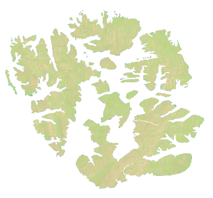
Unmodified Svalmel map asset: OpenFront / OpenFront Inc. and Contributors, CC BY-SA 4.0; source in OpenFrontIO v0.33.7.

Verified Normal topology
| Metric | Value |
|---|---|
| Grid | 1,700 x 1,580 |
| Playable land | 1,011,623, or 37.66% of grid |
| Impassable cells | 0 |
| Land components | 26 |
| Components at least 1,000 tiles | 13 |
| Largest component | 35.28% of playable land |
| Top four components | 91.48% combined |
| Water components | 1 |
Svalmel is not a uniform cloud of equally small islands. Four main land groups hold 91.48% of playable land. The two largest alone hold 66.21%.
That creates four primary theatres plus satellites. Winning one large island is meaningful, but it does not produce a land border into the other three.
All water cells form one connected network. Transport and fleet movement can link the theatres in principle, while route length and hostile naval control decide whether the link is practical.
The largest two components are 35.28% and 30.93%, so the data does not justify calling the map perfectly symmetric. Test spawn pressure before using it as a balance claim.
Svalmel opening questions
- Which main island holds your spawn, and how much expansion remains on it?
- Is your first rival on the same component or across water?
- Which coast gives access to more than one major theatre?
- Can you delay a Port without becoming trapped on one island?
- Which satellite island is a useful staging point rather than an economic distraction?
Compact Svalmel uses 850 x 790 terrain, 248,032 playable land tiles, and 24 land components. The main structure survives while minor island detail is reduced.
Case study: Dyslexdria
Formal v31 calls Dyslexdria a returning April Fools map based on a recolored World. The current v33.7 asset includes later v33 updates and should be treated as the active version.
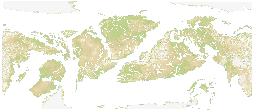
Unmodified Dyslexdria map asset: OpenFront / OpenFront Inc. and Contributors, CC BY-SA 4.0; source in OpenFrontIO v0.33.7.

Verified Normal topology
| Metric | Value |
|---|---|
| Grid | 3,308 x 1,440 |
| Playable land | 2,103,254, or 44.15% of grid |
| Impassable land-bit cells | 175,320 |
| Land components | 224 |
| Components at least 1,000 tiles | 52 |
| Largest component | 16.77% of playable land |
| Top ten components | 85.78% combined |
| Water components | 1 |
No single landmass dominates Dyslexdria. The largest holds 16.77%, and ten major regions are needed to reach 85.78%.
Regional victory is therefore not global control. A player can become strong inside one theatre while remaining unable to reinforce another without crossing water.
The raw 224-component count contains much small-island noise. Focus on the top ten and use the remaining fragments as staging, escape, or distraction terrain.
The 175,320 impassable cells are excluded from the playable-land capacity input. Black or background regions in the thumbnail must not be counted as empty conquerable land.
Dyslexdria defines 82 main Nations: 69 positioned and 13 without coordinates. It also has 189 additional fallback names. Normal public default can use all 82; Compact default uses 20. None of those numbers is a human cap.
Compact Dyslexdria uses 1,654 x 720 terrain, 508,102 playable land, 43,913 impassable cells, and 142 land components. It keeps the multi-theatre identity while removing many minor fragments.
Turn map reading into an opening
Use a short decision sequence after spawning.
1. Name your land component
Decide whether you are on the main landmass, one of several peers, a peninsula, or a satellite island. This tells you whether land expansion alone can reach the centre of the match.
2. Mark the first two exits
Choose a primary expansion lane and a fallback. An apparent exit blocked by impassable terrain is not a fallback.
3. Count meaningful neighbors
Ignore distant names that cannot touch your component soon. Prioritize players who share your land, then players who can reach the same coast or narrow passage.
4. Decide whether water is access or exposure
A useful coast opens more theatres than it exposes. A bad coast consumes Gold on naval infrastructure while one land rival attacks the only border that matters.
5. Set a stop line
Do not expand until every border becomes equally weak. Stop where terrain narrows, defense can overlap, or a Port can connect the next theatre.
The first-match guide expands this into a complete spawn and first-expansion workflow.
Read common topology families
One dominant landmass
Expect continuous borders and several land neighbors. Interior growth and border shape matter more than early transports.
Do not assume the centre is best. Central land often trades access for a larger number of fronts.
Several major islands
Treat each island as a regional economy and each coast as a transfer decision. Secure enough local land before funding every possible naval route.
Svalmel is the verified example: four major components contain most land, with one shared water network around them.
Long corridor or river strip
Front direction is constrained, but distance can be enormous. Depth behind the front matters, and one blocked route can isolate reinforcements.
Grid area alone hides this shape. Passage’s 6,000 x 400 dimensions are a clear warning to inspect aspect ratio.
Fragmented world
Several large components create independent wars. Information and transport timing matter because local strength cannot instantly answer a distant threat.
Dyslexdria is the verified example: the largest component holds less than one sixth of playable land.
Multiple disconnected waters
Ports in different water components support separate fleets and trade systems. Building strength in one does not protect the other.
Confirm actual water components instead of assuming two blue regions connect beyond the edge; v33.7 maps do not wrap.
Common mistakes
Choosing a spawn from visual size alone
A large-looking region may include impassable background or split into several components. Check playable exits before committing.
Calling every narrow shape a chokepoint
A useful chokepoint needs a passable route, defensible width, relevant traffic, and a position you can actually hold. A thin line in a thumbnail proves none of those by itself.
Building a Port because water is nearby
Water access has value only when it reaches a useful theatre and you can survive the opportunity cost. Coast adjacency is not a trade-income formula.
Confusing Nations with players
Nation manifests control AI identities and some fixed spawn coordinates. Human slots come from lobby configuration.
Reusing a Normal plan on Compact
Major geography remains, but small islands, player tiers, bots, Nations, and distances change. Recheck contact order instead of scaling every timestamp by two.
Claiming a best spawn without match evidence
Static topology can identify options and risks. It cannot supply win rates or control for player skill, teams, and modifiers.
FAQ
What should I check first on an unfamiliar map?
Identify your playable land component and two real exits. Then check which water network your coast touches and whether any visible barrier is impassable.
Does one water component mean naval play is easy?
No. It means a continuous water path exists. Distance, enemy fleets, Port access, and pathfinding still decide whether the route is useful.
Are more land components always better for naval play?
They create more reasons to transport, but not necessarily better economics. Tiny islands can add route overhead without enough land to repay infrastructure.
Can topology tell me the best spawn?
It can rule out false assumptions and describe tradeoffs. A best-spawn ranking needs repeated match evidence under the same mode and population.
How does Compact affect topology?
It loads half-width, half-height terrain for one-quarter grid size. Major components usually remain, while small islands and fine coastal detail can disappear.
Why count impassable land separately?
Its land bit can make it look like land in raw counts, but it cannot be owned and is excluded from playable-land capacity. It also blocks attacks, nukes, and nuke trajectories.
Sources and next reading
Related content
Learn how to take small footholds, close an enemy pocket, and keep a second route after the capture instead of turning a lead into a fragile border.
- When Should You Build Each Structure in OpenFront?
A plain-language guide to building Cities, Factories, Ports, Defense Posts, Missile Silos, and SAMs at the right time in OpenFront.
Aug 23, 2026
- OpenFront Defense Posts: Placement, Timing, and Depth
Decide when a Defense Post is worth 50,000 Gold, where its 30-tile coverage matters, and when a second line beats stacking one location.
Sep 2, 2026
- OpenFront Beginner Guide: Build a Strong First Match Step by Step
A step-by-step OpenFront first-match guide: choose a safe spawn, expand without draining troops, protect the first border, and know what to build in the opening.
May 12, 2026